|
|
|
|
Организация Объединенных Наций, признавая природные бедствия в качестве главной угрозы человеческой жизни и развитию человечества, провела под своей эгидой в период 1990-2000 гг. Международную Декаду по уменьшению ущерба от природных бедствий. Цели Декады состояли в том, чтобы на основе применения достижений современной науки и новых технологий повысить во всем мире осведомленность населения о природных бедствиях, способствовать уменьшению и предотвращению причиняемого ими разрушений. Научный и технический комитет Декады в качестве необходимой меры реализации стратегии уменьшения риска признал целесообразным осуществить международные демонстрационные проекты, разработанные для улучшения достоверности оценок опасности стихийных бедствий (землетрясений, вулканов, тропических циклонов, наводнений и т.п.). Среди ключевых программ, принятых в рамках Декады, явились предложения Международной программы по изучению литосферы (МПЛ) осуществить Программу оценки глобальной сейсмической опасности (GSHAP). Эта Программа была официально учреждена в июне 1992 года в Риме на Международном совещании по разработке технической политики GSHAP, в работе которого приняла участие и российская делегация, в состав которой вошел и автор этих строк.
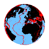
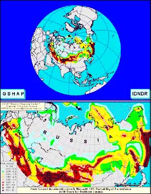
Международная программа GSHAP (главный научный координатор - профессор Доменико Джиардини / Domenico Giardini /, Италия), в которой принял участие и ИФЗ (регион 7 - Северная Евразия, координатор В.Уломов) была начата под эгидой ООН / ЮНЕСКО (UN / IDNDR) в 1992 г. и завершена в 1999 г. публикацией карты Глобальной сейсмической опасности - GSH MAP, одним из фрагментов которой явилась карта, составленная нами для Северной Евразии (слева). Программа GSHAP обосновывала свою значимость тем, что сейсмическая опасность и уязвимость от землетрясений по мере урбанизации и увеличения площади используемых сейсмоактивных территорий, постоянно возрастает. Неконтролируемый рост городов во многих регионах с высоким уровнем сейсмической активности часто осуществляется путем строительства зданий без принятия каких-либо мер сейсмической защиты и без учета необходимой информации о существующей сейсмической опасности. Умеренные и даже слабые землетрясения могут превратиться в катастрофические в районах, где не было принято достаточных мер по обеспечению сейсмостойкости строительных сооружений. В то время как кратко- и среднесрочное предсказание землетрясений, если и поможет когда-то в будущем значительно уменьшить количество человеческих жертв, вызываемых землетрясениями, то эффекты в среде обитания человека (разрушение зданий и инфраструктур, нарушение производственных связей, разрушение жилищ, экономические и экологические последствия) могут быть уменьшены только путем проведения в районах, подверженных воздействию землетрясений, долгосрочной политики, основанной на: - оценке сейсмической опасности; - применении норм сейсмостойкого строительства; - повышении уровня осведомленности населения об опасности природных бедствий; - стратегии землепользования, принимающей во внимание сейсмический риск и возникновение других видов стихийных бедствий. Важно, чтобы властям, принимающим решения, и инженерам, планирующим землепользование и улучшающим проектирование зданий и сооружений, были доступны надежные оценки сейсмической опасности. На первом же совещании в 1992 г., в Риме, одним из девяти Международных сейсмологических центров GSHAP был утвержден Московский центр - Институт физики Земли РАН. Программа GSHAP охватила большую часть приоритетных и стратегических направлений Декады, заполняя существующую во многих странах брешь в попытках правильных оценок сейсмической опасности их территории, необходимых для осуществления стратегии уменьшения риска. Программа ориентировалась на регионально координируемый и унифицированный подход к оценке сейсмической опасности. Конечным результатом реализации Программы предусматривалось получение к концу Декады оценки сейсмической опасности территории различных стран. Предполагалось, что применение на практике правильных оценок сейсмического риска позволит заблаговременно сконцентрировать усилия на предупреждении негативных последствий землетрясений, а не на их последующем устранении, как это обычно делается. Программа GSHAP и Декада UN / IDNDR предоставили хорошую возможность улучшить глобальную оценку сейсмической опасности путем: - координации национальных усилий в межнациональных региональных проектах; - достижения консенсуса в научной методологии оценки сейсмической опасности; - гарантирования, что самые передовые технологии будут широко доступны через программы обмена технологиями и образовательные программы. Программа координировалась на глобальном и региональных уровнях. Управление и администрирование осуществлялось на четырех уровнях: (1) Руководящий комитет, (2) Координационный центр, (3) Региональные центры и (4) Национальные организации. Региональные центры являлись ключевым звеном Программы и функционировали на базе головных геофизических институтов в следующих основных сейсмоактивных регионах мира (в скобках -местоположение центра): 1. Северная и Центральная Америка (Мехико); 2. Южная Америка (Сантьяго); 3. Центральная Европа (Потсдам); 4. Запад Средиземноморья (Рабат); 5. Континентальная Африка (Найроби); 6. Средний Восток (Тегеран); 7. Северная Евразия (Москва); 8. Центральная и Южная Азия (Пекин); 9. Восточная Азия - Океания (Манила). Первое межрегиональное совещание GSHAP по территории Северной Евразии было проведено нами в сентябре 1993 года в Кубинке, под Москвой, при участии и финансовой поддержке Координационного комитета GSHAP и МИННАУКИ России. В нем приняли участие представители 14 стран Евразии - Азербайджана, Беларуси, Вьетнама, Германии, Индии, Италии, Китая, Марокко, России, Туркменистана, Украины, Финляндии, Франции и Швейцарии. Наряду с другими принятыми и важными для GSHAP решениями тогда же, по предложению автора этих строк, было принято решение об организации Крым-Кавказ-Копетдагского тестового полигона, в исследованиях на территории которого приняли в дальнейшем участие сейсмологи из России, Ирана, Украины, Турции, Грузии, Армении, Азербайджана, Туркменистана и Узбекистана. Финансовая поддержка работ по реализации Программы оценки глобальной сейсмической опасности осуществлялась Международным комитетом научных союзов (ICSU), а также странами-участницами GSHAP, в том числе - МИННАУКИ России. Наряду с этим тестовый Крым-Кавказ-Копетдагский полигон был поддержан INTAS (Ct.94-1644). В результате были созданы: объединенный региональный каталог землетрясения (исторический и инструментальный), новая модель сейсмических источников и сейсмического зонирования, на основе вероятностно-детерминированной и вероятностной методологии. Были проведены тематические симпозиумы в Тегеране (январь 1993), Москве (сентябрь 1993), Ашхабаде (октябрь 1994), Тегеране (май 1995), Ереване (июль 1996) и в Тбилиси (июль 1997). Всесторонний анализ результатов работ на этом тестовом полигоне был осуществлен в июле 1996 г. в Армении при поддержке НАТО (ARW), завершившийся публикацией крупной монографии "Исторические и доисторические землетрясения на Кавказе" (Ct.95-1521), изданной всемирно известным издательством Kluwer. Весь ход исследований по GSHAP широко освещался на страницах Интернет (см. GSH MAP).
Литература В.И.Уломов. Моделирование зон возникновения очагов землетрясений на основе решеточной регуляризации // Физика Земли. 1998. № 9. С. 20-38. В.И.Уломов, Л.С.Шумилина. Сейсмическое районирование России на основе автоматизированных технологий // Проект. 1998. №3. С. 4-8. V.I.Ulomov. On the identification and seismological parameterization of earthquake source zones. The Caucasus and adjacent area // Historical and Prehistorical Earthquakes in the Caucasus. NATO ASI. Series 2: Environment - Vol. 28. ILP Publication n.333. Kluwer Academic Publishers: Dordrecht / Boston / London. 1997. Р. 503 -522. V.I.Ulomov. NATO Advanced research workshop on historical and prehistorical earthquakes in the Caucasus // Izvestiya, Physics of the Solid Earth, Vol. 33, No. 3, 1997, pp. 255-256. V.I.Ulomov. Seismic hazard of northern Eurasia. (Coauthors L. Shumilina, V. Trifonov et al.) // Annali Geofis.. Vol. 42. 1999. P. 1023-1038. Test Area for Seismic Hazard Assessment in the Caucasus (Coauthors Giardini, D., Balassanian, S., Gassanov, A., Chelidze, T., Pustovitenko, B., Ashirov, T., Ghafory-Astiani, M. , Erdik, M., Kondorskaya, N., Trifonov, V., Molchan, G., Schenk, V., Mayer-Rosa, D., Stucchi, M., Grunthal,G. // Roma, National Geophysical Institute 1997. 73 s. Grant: GA AV(CZ) INTAS Ct. 94-1644 V.I.Ulomov. Seismic Hazard of Northern Eurasia. Moscow GSHAP Regional Center Contribution // http://seismo.ethz.ch/hazard/gshap/neurasia. 1998. Zurich. 22 p.
Seismic hazard of the Northern Eurasia
V.I.Ulomov. GSHAP Moscow Regional Center Coordinator, Schmidt United
Institute of Physics of the Earth, Russian Academy of Sciences, B.Gruzinskaya, 10, Moscow 123810 GSP, Russia.
Introduction. The Moscow Regional Center (United Schmidt Institute of
Physics of the Earth - UIPE) of the Global Seismic Hazard Assessment Program
(GSHAP) was founded in 1992 after GSHAP Technical Planning Meeting in Rome.
However, investigations adequate to GSHAP started in former USSR (CIS, now)
in 1991, directed by the UIPE (Prof. V.I.Ulomov, Coordinator). The studied
territory of Northern Eurasia (GSHAP Region 7) covers the area 30-90° N, 20°
E-170° W degrees and includes whole territory of Russia and other republics
of former USSR, and also contiguous seismically active areas. The total
number of participants of these investigations were more than 30 research
institutes of Russian Federation and other CIS-countries.
Beginning from 1993 the GSHAP Regional Centers for Northern Eurasia (the
UIPE of Moscow) and for the Middle East (the IIEES of Tehran) have joined
efforts in the Crimea-Caucasus-Kopetdagh test area. It has been proposed by
GSHAP and jointly supported by IASPEI/ESC/INTAS, and includes the
seismological institutions from the Caucasian republics, Russia, Ukraine,
Turkmenistan, Italy, Czech, Turkey, Iran and others countries. Workshops
have been held in Tehran (1/1993), Moscow (9/1993), Ashgabad (10/1994),
Tehran (5/1995), Yerevan (7/1996) and Tbilisi (7/1997). The Caucasus
activities are supported by INTAS under 94-1644. The Yerevan WG (7/1996) was
supported by NATO-ARW. The Moscow GSHAP Regional Center and Beijing Regional
Center for the Central-Southern Asia (the SSB of Beijing) have joined
efforts in the Central Asia, Mongolia and Far Eastern regions. Workshops
have been held in Beijing (4/1993 and 10/1994) and in Moscow (4/1996 and
9/1997). The similar international working meeting on creation of the map of
earthquake source zones of Central Asia (as the fragment of the Northern
Eurasia GSHAP Region 7) have been held in Bishkek (9/1995). It was organized
by UIPE and Institute of seismology of Academy of science of Kyrgyz Republic
by financial support of Russia. In this meeting the representatives from
Uzbekistan, Kyrgyzstan, Russia, Kazachstan and Tadzhikictan have accepted
participation.
Methodology. The methodology for seismic hazard zoning developed in UIPE
is based on the two-stage principle implying the creation of two mutually
related probable models: a model of source zones (MSZ) and a model of
seismic effect (MSE). This methodology includes the technology of operations
with 2D and 3D source zones and adequate reflects the nature of seismicity.
The denotation of this method is «Earthquake Adequate Sources Technology -
EAST-97» and based on lattice regularization and on the conception of: (a)
fractal structural-dynamic unity of the medium and the seismic processes in
it; (b) upper threshold for magnitude stipulated by geoblock sizes, hardness
and intensity of their interactions; (c) deterministic-probabilistic
approach to all input and output data.
According to the program were created several working groups
coordinated
by following Russian scientists:
Geodynamics and Seismicity. The seismicity of Northern Eurasia stipulated
by intense geodynamic interaction between eight large lithosphere plates:
European, Asian, Arabian, Indian, Chinese, Pacific Ocean, Okhotsk Sea and
Northern-American. The structural and historical regularities of tectonics
and geodynamics established over such the vast territory of Northern Eurasia
allow to consider them as planetary system. They are expressed in
heterogeneity of recent tectonic structure, starting with the lithosphere
and terminating in regional subdivisions. It is necessary to do the
investigations of the tectonic objects of various hierarchical rank clearly
distinguishing their static and dynamic characteristics. The Earth crust of
platforms characterized by 40 - 50 km thickness, but in the continental
orogenic belts Moho discontinuity situated on the depth 60 km and more. The
orderliness exhibited by the regional structure of global seismicity shows
that a close connection exists between intracontinental seismic regions and
relict subduction zones. The Northern Eurasia includes the platform
territories (East-European or Russian, West-Siberian and Siberian) with very
low and diffuse seismicity, and several orogenic regions with higher
activity (Iran-Caucasus-Anatolia, Central Asia, Altay-Sayany-Baikal region
etc.) and legible structured seismicity. Kuril-Kamchatka subduction zone is
most geodynamic and seismic active region with depth of earthquake
hypocenters 600 km and more. The Carpathians and Pamir-Hyndukush relict
subduction zones produce intermediate focus earthquakes with depth of
hypocenters till to 150 and 300 kms respectively.
Basic earthquake catalogue of Northern Eurasia adopted for the GSHAP
Project is the «Specialized Earthquake Catalogue of Northern Eurasia» (SECNE),
which was created under the National Research Program «Seismicity and
Seismic Zoning of Northern Eurasia». The SECNE includes more than 30
thousand events with moment magnitude Mwі 4.5 from ancient times until 1995.
Specific attention was devoted to the reconciliation of differences and
coordination of parameters of earthquakes occurring on the adjacent
territories. It is essential for identification of earthquake-generating
features and for the assessment of their seismic potential to map earthquake
sources in accordance with their dimensions and orientations rather than
point epicenters. Earthquake sources of М=>7 (М=>6.8) are shown to the
realistic size on the map scale as ellipses having long L and short W axes
according to formulas logL = 0.6M – 2.5; logW = 0.15M + 0.42 and for
interval 4.0<=M<=6.5 - as circles of decreasing diameter.
According to Regionalization of Northern Eurasia the four
main sectors (East Europe; Central Asia; Central Siberia; East Asia) include
the seventeen seismotectonic regions characterized by specifically seismic
regime. The interval 4.0<=M<=6.0 of earthquakes in each regions of Northern
Eurasia characterize by exponential frequency-magnitude relationship, but
the nonexponential distribution of events is the attribute of magnitude
range M=>6.5. Earlier this factor was ignored by compilers of former seismic
zoning maps and in result, in particular, the return period of large
earthquakes in 3-5 and more times was decreased.
Earthquake Source Zones. According to developed in UIPE the
Lineament-Domain-Focal (LDF) model of seismic source zones (SSZ) a main
structural unit of global seismicity - is a region. Each region include the
seismic structure of three types: lineaments, domains and potential
earthquake sources. Seismic lineaments constitute the frame of the SSZ model
and show the axes of earthquake-generating features. The sources do not
settle down strictly lengthwise of lineaments and deviate them in both sides
on distances depended from magnitude of earthquakes, generated by them.
Domains are represented as quasi-homogeneous seismotectonic areas in which
impossible to identify whichever lineaments. Potential earthquake foci
identified by various methods are mostly confined to lineaments.
Seismic source zones are classified, similarly to earthquakes, according
to the following magnitude intervals: M=8.5+-0.2; 8.0+-0.2; 7.5+-0.2; 7.0+-0.2; 6.5+-0.2; 6.0+-0.2; 5.5+-0.2; 5.0+-0.2; 4.5+-0.2; 4.0+-0.2. The regional seismic rates are adequate
distributed between all structures of various ranks: events with М=>6.0
belong to lineaments proportionally to their common length and potential
sources, while those of М<=5.5 to domains.
In all, 580 lineaments with M=>6.0 (including more than 1000 their short
segments), 442 domains with M<=5.5 and 11 potential foci with M=>7.0 were
specified on the territory of the Northern Eurasia.
Strong Ground Motion. The Intensity-Distance-Magnitude relationship I(D,
Mw) is simulated using a simple theoretical model calibrated using observed
macroseismic data for the whole Northern Eurasia. In the vicinity of the
source the model describes consistently the amplitude saturation around a
fault. The elongated shape of first isoseismals is modeled automatically.
The scatter of I(D, Mw) relationship is produced by variations of source
radiation capability at a given Mw, and by variation in propagation path and
near-receiver structure (ground) effects. The sources are modeled as two
normal distributions with zero mean and standard deviations of sigma 0.5 and
0.8 respectively. These values were estimated approximately from actual
macroseismic data.
Seismic Hazard Computation and Zoning. The method developed in UIPE
follows the usual lines of Yu.V.Riznichenko (1965) and C.A.Cornell (1968).
The technique includes however several improvements as compared to typical
techniques:
For the Seismic Hazard Map of the Northern Eurasia in the terms a peak
ground accelerations (PGA) it was agreed to convert intensity to PGA in m/s/s using the empirical relationship: logA(m/s/s)=0.333 I(MSK) – 2.222. It has
allowed correctly to take into account effect from extended seismic sources.
The calculation grid for the PGA with 10% probability of exceeding in 50
years is 25 km x 25 km for whole Northern Eurasia. This PGA map was created
on the base of the complete set of seismic zoning maps (10%, 5% and 1%
probability with 10% probability of exceeding in 50 years) accepted now in
Russia as the normative documents for Building Code in application to
construction of different categories of significance and life (A, B, C). As
has shown the analysis of the created PGA map, it largely more correctly
reflects natural conditions in comparison with all previous maps of seismic
zoning.
The more detailed outcomes of Moscow GSHAP Regional Center can be found
on the Internet:
http: //seismo.ethz.ch/hazard/gshap/nordasia
Bibliography.
Global Seismic Hazard Assessment Program, Annali di Geofisica, Spec.
issue: Technical Planning Volume of the ILP`s, 1993, XXXVI, 3–4, 257p.
Ulomov, V.I., Structural and dynamical regularity of Eurasia
intracontinental seismicity and some aspects of seismic hazard prediction,
XXIV General ESC Assembly, 1994 September 19-24, Proceedings and Active
Report 1992-1994, vol. 1, Athens, Greece, pp.271-281.
Shebalin, N.V., Ulomov, V.I., Tatevossian, R.E., Trifonov, V.G., Ioffe,
A.I., Kozhurin, A.I., Unified Seismogeological Taxonomy of the Northern
Eurasia, IUGG-Abstracts, Boulder, U.S.A., 1995, SB21C-14.
Ulomov, V.I., Seismic hazard assessment in Northern Eurasia,
IUGG-Abstracts, Boulder, U.S.A., 1995, SB51D-3, pp.B-404.
Ulomov, V.I., Non-linear dynamics of fractal geostructure and fractal
lattice model of the seismogenesis, Abstracts of ESC, Reykjavik, Iceland,
1996, E1.22, p.71.
Ulomov, V.I., On the identification and seismological parameterization of
earthquake source zones, The Caucasus and adjacent area, Historical and
Prehistorical Earthquakes in the Caucasus (edited by Domenico Giardini and
Sergiei Balassanian), NATO ASI, Series 2: Environment – Vol. 28, ILP
Publication n.333, Kluwer Academic Publishers, Dordrecht / Boston / London,
1997, pp.503-522.
Ulomov, V.I., Focal Zones of Earthquakes Modeled in Terms of the Lattice
Regularization, Izvestiya, Physics of the Solid Earth, 1998, vol. 34, no. 9,
pp.717-733.
|
|
|